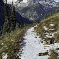
Frost on the trails this morning is signaling a shift in the seasons. We expect early season mountain snowfall with the next system that comes through and with it the potential to groom something up the hwy 20 corridor. Stay tuned for updates when we have temps and snowfall amounts to get the rust off the old groomers and your dust off your skis.
Our crews are hard at work mowing, repairing bridges, thinning and buffing out the trails for your summer enjoyment as well as getting ready for winter snowfall.
Winter passes are on sale now and it's a great time to lock in the early season pricing on what is forecast to be a good winter. You have 30 days to pick up your pass at early season rates so don't miss out.
---
Snow at Easy Pass by Gerald Smith. Winter is coming!
Rendez Vous
| ABC | Distance | Open | Last Groomed | |
|---|---|---|---|---|
Buck Mountain | 15.62km | |||
Buck Mountain FS Road | 4.45km | |||
Buck Up | 5.34km | |||
Cassal Creek Loop (black) | 0.75km | |||
Cassal Creek Loop (blue) | 1.72km | |||
Cassal Hut | 0.81km | |||
Cedar Creek Loop (black) | 1.87km | |||
Cedar Creek Loop (blue) | 4.14km | |||
Cougar Bait | 1.32km | |||
Cougar Mountain Loop | 4.64km | |||
Cow Creek | 4.23km | |||
Cub Creek | 3.47km | |||
Grizzly Hut | 0.47km | |||
Grizzly Mountain Loop | 1.59km | |||
Grizzly Way | 1.09km | |||
Gunn Ranch | 4.93km | |||
Heifer Hut | 1.26km | |||
Little Cub Creek | 5.22km | |||
Lower Fawn Creek | 4.77km | |||
Lower Rendezvous Basin | 1.48km | |||
Lower Rendezvous Pass | 2.57km | |||
Rendezvous Basin | 2.29km | |||
Rendezvous Pass | 1.12km | |||
Sick Joke Hill | 2.14km | |||
Upper Cougar Bait | 4.13km | |||
Upper Fawn Creek | 2.5km |
Mazama
| ABC | Distance | Open | Last Groomed | |
|---|---|---|---|---|
Cassal Cutoff | 0.79km | |||
Doe Canyon | 2.21km | |||
Doe Canyon Loop | 0.51km | |||
Early Winters | 0.59km | |||
Founders Trail | 4.27km | |||
Goat Creek | 1.68km | |||
Goat Creek Cutoff | 0.73km | |||
Inn Run Loop | 1.86km | |||
Jack's | 4.69km | |||
Lower River Run | 1.4km | |||
Lunachik | 1.6km | |||
Methow Community Trail- Browns Farm to Suspension Bridge Trailhead | 5.58km | |||
Methow Community Trail- Wolf Ridge to Browns Farm | 2.66km | |||
Methow Valley Community Trail- Browns Farm to Suspension Bridge Trailhead | 0.07km | |||
Methow Valley Community Trail- Mazama to Freestone Inn | 3.22km | |||
Sandy Butte | 1.76km | |||
Tawlk-Foster Suspension Bridge | 0.07km | |||
Upper Jack's | 2.5km | |||
Upper River Run | 3.8km | |||
Wolf Creek Road | 8.56km |
Sun Mountain
| ABC | Distance | Open | Last Groomed | |
|---|---|---|---|---|
Aqua Loop | 2.01km | |||
Beaver Pond | 1.78km | |||
Black Bear | 5.34km | |||
Blue Jay | 3.09km | |||
Cabin | 0.86km | |||
Chickadee | 1.1km | |||
Climb It Change Lower | 2.34km | |||
Climb-It Change Upper | 2.39km | |||
Coal Creek Trail | 8.36km | |||
Criss Cross | 1.1km | |||
Homestead | 0.41km | |||
Horse Trail | 0.94km | |||
Kraule | 1.83km | |||
Little Wolf | 2.48km | |||
Lower Fox | 0.86km | |||
Lower Inside Passage | 1.42km | |||
Meadow Lark | 4.98km | |||
Moose | 0.83km | |||
More Cowbell | 2.94km | |||
Overland | 1.52km | |||
Patterson Lake | 2.4km | |||
Patterson Mountain | 4.51km | |||
Pete's Dragon | 4.24km | |||
Rader Creek | 2.21km | |||
Raven | 0.22km | |||
Red Tail | 1.91km | |||
Rodeo | 1.69km | |||
Shortcut | 0.38km | |||
Sunnyside | 3.09km | |||
Thompson Pass | 1.48km | |||
Thompson Ridge | 20.18km | |||
Upper Fox | 0.75km | |||
Upper Thompson Ridge | 2.39km | |||
View Ridge | 2.4km | |||
Wild Turkey | 1.72km | |||
Woodpecker | 7.72km | |||
Yellow Jacket | 1.88km |
Big Valley
| ABC | Distance | Open | Last Groomed | |
|---|---|---|---|---|
Big Valley (Inner Loop) | 2.43km | |||
Big Valley (Outer Loop) | 4.24km | |||
Forest Road 5130-100 | 1.95km | |||
Lewis Butte Trail | 5.65km | |||
National Forest Development Road 155 | 2.74km | |||
Rizeor Lake Trail | 6.01km |
Winthrop
| ABC | Distance | Open | Last Groomed | |
|---|---|---|---|---|
Fish Hatchery | 0.09km | |||
Meadowlark | 3.28km | |||
Methow Community Trail- Powers Plunge to Wolf Ridge | 1.5km | |||
Methow Community Trail- Winthrop to Powers Plunge | 0.84km | |||
Methow Valley Community Trail- Winthrop to Powers Plunge | 0.43km | |||
Powers Plunge | 2.02km | |||
Rex Derr Trail | 7.76km | |||
Susie Stephens Trail | 0.49km | |||
TWiN | 1.88km | |||
Winthrop Fatbike Snowshoe | 0.11km | |||
Winthrop Trail (Lower) | 3.29km | |||
Winthrop Trail (Upper) | 2.78km |


